Drones for Disaster Management in Pakistan
By haadshaikh
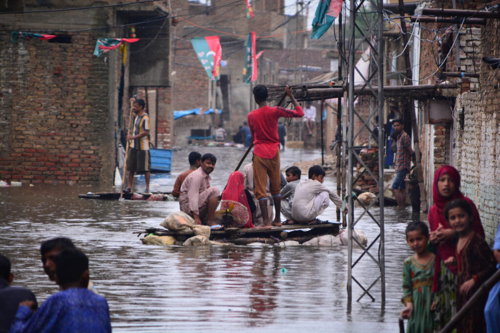
During the Pakistan floods of 2022, DroneServ deployed it’s fleet of drones to identify potential areas for air drops and used unmanned aircrafts carrying payloads for delivering key medicines to victims.
Pakistan’s Geography
Bordered by India to the East, China to the North, Iran and Afghanistan to the West, Pakistan is situated in the South Asian region. Pakistan is a geographically diverse country – it’s rich diversity of landscapes span from the soaring mountain range in the northwest, followed by valleys to barren plateaus and the Indus River plain, which flows southward all the way into the Arabian Sea.
Disasters in Pakistan
Pakistan is home to a vast geography. The country is however seriously affected by global climate change and environmental degradation. With so much rainfall and poor infrastructure, floods hit Pakistan every year. According to the Climate Risk Index 2021, Pakistan is ranked eighth for countries most affected by global climate change even though contributing to even less than 1% of it.
Floods
Since 2010, Pakistan has been hit by a succession of floods. In this country, flood dangers are at an all-time high. The recent terrible 2022 flood, caused by intense monsoon rains, wiped away rural and urban developments, leaving about 10 million children in desperate need of emergency lifesaving assistance.
Thousands of houses, schools, hospitals, and water infrastructure have been devastated. The National Disaster Management Authority documented over 1,600 deaths and over 12,000 injuries, including 579 deaths and over 4,000 injuries among minors.
This is only one example of a recent flood. Floods have occurred every year since the 2010 floods, affecting over one-fifth of the country’s territory and leaving around 20 million people without relief who needed quick assistance. The delay in help response resulted in a higher number of victims (out of the 1,985 deaths). The 2010 flood alone caused losses over Rs. 39 billion to the national economy.
Aside from floods, Pakistan confronts natural calamities such as wildfires, droughts, and earthquakes, but no suitable disaster management strategies have been implemented.
Droughts
The United Nations has put Pakistan on the “drought-hit” list. Pakistan is among the twenty-three (23) countries that are facing extreme droughts over the past few years. Several districts in Baluchistan and Sindh face drought conditions resulting in high level of food insecurity and leaving adverse effects on agriculture and livestock.
Extreme drought of 1998 – 2002
This drought is considered the worst drought the country has faced in 50 years. It started in 1997, gained intensity in 1998 and reached its peak in 2000 till 2001 and ultimately lost its effect in 2002. It hit the country’s economy really bad. Around 1.2 million people in just Baluchistan were affected by the drought. In Sindh, 127 people died as a result of severe water shortages and heat strokes.
As a result, tens of thousands of families migrated from Baluchistan and Sindh to irrigated or urban lands. Pakistan has always faced a drought every two years be it a moderate or a week drought. In 2022, the National Drought Monitoring Centre issued a drought alert alerting about a potential drought in the summers due to the increased average temperatures and little or no precipitation.
Earthquakes
The most seismically active country, Pakistan is crossed by several major faults due to which destructive earthquakes occur very often in Pakistan.
The most destructive earthquake in the history of Pakistan was the October, 2005 earthquake with a magnitude of 7.6. It claimed about 79,000 lives and 32,000 buildings collapsed in Kashmir
Pakistan’s Response to the Disasters
Something interesting to note is that although Pakistan has been facing these issues for a long time, there’s always zero preparation when it comes to pre-disaster measures or even post-disaster measures. After all, disaster management is more about preparedness than response. Floods and the drastic change in climate are preventable if there’s a check on deforestation activities, illegal constructions alongside rivers and construction of more and more dams.
Pakistan, being a developing country that is economically and politically suffering, has historically relied on foreign funding to mitigate the effects of natural calamities such as flash floods, earthquakes, and forest fires. Pakistan’s disaster response system, even though it exists and is working, is not always prepared for pre-disaster precautions because it is a struggling country.
When it comes to post-disaster measures, aid response is often delayed, placing impacted people in a dire scenario. Once the roads are cleared, the only method to bring relief to the affected people is via helicopter or vehicle (which takes forever when it comes to floods or earthquakes). Monitoring of floods and water levels, for example, has always been done by satellite, despite the fact that in this current age of technology, many more cost-effective and widely accessible substitutes are available.
Are Drones a Solution for Disaster Management?
Drones and their applications have swiftly evolved over the last several years in a range of sectors from commercial, agricultural, industrial to disaster management and humanitarian aid. They can remotely operate in disaster areas that are normally inaccessible to humans or rescue vehicles.
Disasters are notorious for sowing the seeds of loss. The inevitability of calamities prompts the implementation of provocative safety measures. With life and death on the line, disaster management and quick response relief services cannot be overlooked. The importance of drones in such scenarios cannot be emphasized.
Drones may be utilized in a variety of disaster management scenarios. Some of these are discussed below:
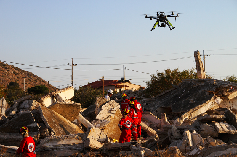
1. Search and Rescue
When lives are at stake, every second matters. For those trapped beneath the rumbles of the catastrophes, each second feels like a lifetime, every second counts.
Traditionally, helicopters or small aircrafts were used on a large scale to help in search and rescue from above, but in disasters such as earthquakes or flooding, airfields and helipads are frequently destroyed and unfit for use. Even if they are active, it takes them longer to commence rescue efforts, particularly in developing and economically suffering nations such as Pakistan.
This method of spotting and rescuing also relies on spotters looking down from a high platform with binoculars.
Drones facilitate fast, efficient, and effective search and rescue operations. They account for quick relief since calamities necessitate immediate aid and relief.
They come with a plethora of useful features that boost the effectiveness of the operation, allowing first responders to carry out their rescue services much earlier and more effectively.
Drones can cover broad search grids; for example, during flash floods, drones may provide a birds-eye view of where the water is moving, predict where it will rise, and locate trapped individuals. Responders can discover heat signatures, identifying people buried beneath the rumbles of a catastrophe, using the attached thermal cameras and spotlights. Thermal cameras can detect a person in the water up to 50 meters away. Drones can also autonomously identify people and send back the information marking GIS (geographical information system) coordinates of the site where people were found including a headcount. With the help of this information, the rescue department will be able to initiate its rescue services immediately.
The 2008 Sichuan earthquake is a real-world example of drones being employed in a search and rescue effort. One of the most devastating earthquakes in human history. Drones were employed to assist rescue teams by identifying collapsed population-dense buildings as well as roads that were closed to on-the-ground personnel.
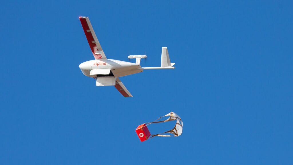
2. Medical Package Delivery
Aid organizations in developing nations have weak or non-existent infrastructure, which is aggravated by disasters such as damaged roads and debris-covered areas, which make it difficult for medical aid teams to access impacted areas. People stranded in regions where rescue will take time require immediate assistance until they are rescued and moved to a safer location.
Drones may not be able to replace conventional 4×4 vehicles or helicopters for humanitarian aid (since they can transport larger supplies), but they can improve the effectiveness of first-aid response by serving as an additional instrument for humanitarian relief.
Payload delivery drones can provide medical supplies, food, sanitary items, and communication equipment. Medical supplies can range from essential pharmaceuticals to vaccinations, water purification tablets, and surgical equipment. The objective with drones is to minimize aid delivery time and to alleviate the suffering of the victims.
During COVID-19, for example, drones were utilized in a global viral outage. People in need received COVID-19 test kits and PPE supplies. Drones cut delivery times from up to six and a half hours via road to only 10-15 minutes.
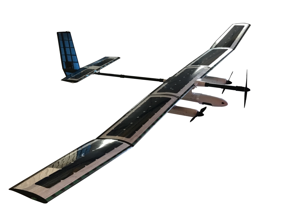
3. Communication Re-establishment
Power line and communication lines are cut off in regions hit by natural disasters. In such areas, a network capable of handling voice channels might be critical for search and rescue activities. Communication infrastructure is critical for communicating disaster and safety information to the general public, coordinating recovery plans among first responders, and re-establishing communication between family members to check in on their loved ones.
A unique type of UAV can be used to re-establish temporary Wi-Fi connections enabling on-the-ground rescue teams to- coordinate rescue preparations. A drone fleet can be deployed (linked together to enhance coverage) in regions of crisis, or they can be linked to a ground-based telecommunication system to boost signal coverage for use by search and rescue workers during an operation where communication is critical.
Integrated Dynamics, a Pakistani UAV manufacturer and service company, has a communication re-establishment UAV dubbed the SOLARIS. A UAV powered by a hybrid of solar and Li-Ion batteries that can stay in the air for several weeks, offering a platform for communication during a disaster or for military objectives.
UAVs can be linked together utilizing directional antennas (which focus signal bandwidth in one direction, boosting coverage from 100s of meters to kilometers) to provide expanded coverage. Finally, Wi-Fi routers provide a wireless connection between the UAV and ground terminals as the source.
4. Remote Situation Assessing and Mapping
Disaster-affected areas cover vast swaths of land or water, are massive and difficult to scale, and may pose an unnecessary risk. Assessing them with human aerial vehicles such as aircraft or helicopters can endanger the pilots and crew and is both costly and time consuming.
Drones, due to their speed and mobility, can assist in assessing damage and reaching remote sites. Drones equipped with high-resolution cameras record real-time images of the disaster while simultaneously gathering and relaying critical data to ground stations.
Drones equipped with 3D mapping and surveying technology can map the impacted areas and collect data to aid in the prevention of future disasters such as flash floods and landslides.
5. Extinguishing Wildfires
Time is of the essence when it comes to wildfire. Makes sense why drones can be the better option when it comes to wildfire response. They are easier to deploy, much faster and much more safer making them more effective as compared to traditional methods.
Every year, firefighters lose their lives to wildfires. In 2013, for example, the United States Fire administration stated that around 34 firefighters died and 29,760 firefighters sustained serious injuries.
Every year, massive forest fires rage in Pakistan amid record-breaking temperatures and severe heatwaves. The worst damaged locations in 2022 were in Baluchistan’s Koh-e-Sulaiman Range. The wildfires damaged over 40% of the entire trees, displacing a large number of people. Similarly, Khyber Pakhtunkhwa has seen many wildfires destroy families who were unaware of the unexpected disaster.
Rescue aircrafts flying at much low altitudes fighting wildfires put the lives of the firefighting crew in risk.
With drones, firefighting duty has become a lot easier. Drones can be used for situational awareness about the fire and its surrounding, assisting fire fighters in assessing the fire. The machines can reach difficult places, provide thermal assessment with the help of thermal cameras and point out potential fire outbreak points.
Drones can also be used, but can never replace aircraft extinguishing services, for extinguishing fires by dropping fire retardants more precisely and safely.
How can Pakistan benefit from Drones for Disaster Management?
Pakistan is prone to natural disasters and has been in the forefront of the countries affected by climate change.
The Pakistani government can, together with other stake holders, use drones for a better perspective on the disaster. It can help them with disaster preparedness, collecting data over time from vulnerable places, analyzing them and acting accordingly.
The government can provide these drones to rescue organizations in Pakistan so that they can conduct search and rescue missions amid flooding, earthquakes, landslides, and wildfires. Because rescue organizations already have offices and deployment sites in disaster-prone areas, drones can be deployed swiftly and easily without the trouble of travelling to the disaster area. They can be used to deliver aid packages to the suffering families which is always on delay in this country.
Pakistan’s economy is in trouble, and the country is already in international debt. Disasters like these, as well as measures to mitigate disaster damage after the fact, may have a significant influence on a country’s already ailing economy. Pakistan has relied extensively on traditional manned aircraft for post-disaster and disaster relief operations. The expenses are not static; when inflation rises, manufacturing prices, fuel costs, and maintenance costs rise significantly. Drones will be a more cost-effective alternative to expensive helicopters or aircraft used for data acquisition and searching since they do not require fuel, do not require costly maintenance, and have a 99% lower production cost. This would alleviate some of the economic strain associated with disaster management.
Recently, the CDA (Capital Development Authority) began to recognize the usefulness and efficacy of drones in wildfire prevention and monitoring by purchasing drones for this purpose as part of its efforts to increase surveillance of Margalla Hills National Park amid rising forest fire incidents.
Unfortunately, countries like Pakistan have yet to find the true potential of drones and use them specifically in disaster management and humanitarian aid services.
DroneServ in Disaster Management so far
DroneServ has actively provided demonstrations in creating awareness on how Drones can be used for Disaster Management. During the Sindh Floods of 2022, DroneServ used it’s fleet of drones to identify potential areas for air drops and deployed its unmanned aircrafts for delivering key medicines to those in need. We offer our drones in such cases and consultation on what drones you can use for your disaster management preparedness.
Have something to add to the blog? Feel free to leave it in the comments below!