Using Drones for Wildlife Conservation in Pakistan
By haadshaikh
Using drones for wildlife applications offers safety for the crew and efficiency in conducting surveys for population counts and monitoring endangered species.

Wildlife conservation is the process of safeguarding wild species and their habitats in order to preserve healthy wildlife populations and to restore, protect, or improve natural environments. Wildlife plays an important role in maintaining the world’s ecosystem, providing an equilibrium to nature’s processes. Wildlife conservation is about enacting the survival of these species and to educate the hoi polloi on living innocuously with these species.
As the human population grows, natural resources are being consumed faster than ever. This leaves animals displaced for land development. Other threats to wildlife include climate change, pollution, poaching (illegal hunting) and fishing.
Worldwide efforts to conserve animals and their habitats are supported on many different fronts by national and international organizations including the World Wildlife Fund, Conservation International, the Wildlife Conservation Society, and the United Nations. They collaborate with the government to create and preserve public areas, such as wildlife refuges and national parks. In addition, these organizations help writing legislations and further work with law enforcement agencies to prosecute wildlife crimes such as wildlife trafficking and poaching,
Pakistan’s Threatened Wildlife
Pakistan’s biodiversity includes 660 bird species and 177 animal species, which live in a variety of habitats at elevations ranging from sea level to high in the mountains. According to the World Wildlife Fund (WWF), Pakistan is home to a diverse flora and fauna however these species are declining at an alarming rate. The country is prey to unsustainable levels of hunting, fishing and harvesting. Many species are endangered and if unchecked, the country may lose these treasured species.
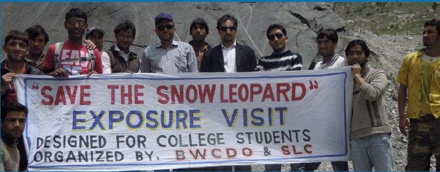
Snow Leopards are an endangered species found in the Hindkush and Karakoram Mountain ranges near Gilgit-Baltistan (north of Pakistan). Today, the estimated population count of snow leopards is less than 400. The Baltistan Wildlife Conservation and Development Organization (BWCDO) works actively with the villagers in protecting the remaining snow leopards. Take a look at this video captured by the BWCDO of a snow leopard family gently passing along a trail in Baltistan, the camera trap further catches three of the cubs playing with one another. It is estimated that only 8,000 snow leopards are left in the wild. Despite this, hundreds of snow leopards are prone to animal trafficking. Organizations such as the BWCDO is doing an outstanding job in creating awareness among the locals of Gilgit-Baltistan who now take pride in the existence of these rare species.
The Markhor also widely known as the ‘national’ animal of Pakistan is considered a ‘near-threatened’ species which means that the markhor population could reach a vulnerable and endangered stage in the near future. The Markhor looks like a goal with “screwed horns”, the animal is a scape-goat for many poachers who find sport in killing the species.
The Markhor population was on the rise but has fallen in recent years due to poaching. The Markhor count now is estimated between 5000 to 6000, however a survey remains to be conducted to estimate a close-to-accurate count.
How Drones can be of assistance in Wildlife Preservation?
Having a bird’s eye perspective of the wild changes everything. Research on forests, wildlife protection has improved significantly with harmless drones deployed in the wild offering constant surveillance of the ground below. Drones can capture information, pictures and data that may be impossible to acquire on-foot to in the first place.
Drones can be used to acquire images, count animal populations, monitor wildlife, plan reforestation and track illicit activity with video surveillance – all of these can be achieved in many ways with different types of drones.
By evaluating forest health, encroachments, tree-felling, forest fires, the status of water bodies, and biodiversity protection, drones for forest and wildlife will help us stay aware of our surroundings like never before. Using drones not only saves labor but makes it safe for both people and the wild. Furthermore, using drones saves more time and allows one to survey an area quickly.
1. Maintaining Animal Population Counts
Unreliable aerial imaging and arduous, time-consuming manual surveys are common tactics used in traditional methods of animal population surveying. To obtain an accurate count, researchers frequently need to go through the animal’s habitat or use binoculars. Using these surveying techniques makes it very difficult to achieve an accurate count because they are so dependent on the weather and animal behavior.
These processes are made simpler using UAV technology, which also delivers extremely accurate data, but how precise is the data? – one might ask. According to a Smithsonian Magazine article, “drone wildlife estimates are 96% more accurate than manual ones.”
In Namibia, researchers are using drones to count the population of Rhinos and Gnus. The AI involved in the project (Project Savmap of 2014) is so great that a single person can complete a full census of the animals in the 100 km reserve in just a week. Similarly, drones are being used all over the world to maintain animal population counts. In Portugal, researchers are watching Eurasian otters; in Nepal, tigers are being tracked and researchers in China are no longer using Panda feces to track them (yes, they’re using drones now).
Livestock management, also known as livestock monitoring or precision livestock farming, uses IoT-enabled devices to track and monitor the health of livestock, most commonly cattle. IoT-enabled livestock management solutions take the guesswork out of herd health. This is done with a wearable collar or tag and battery-powered sensors to monitor the location, temperature, blood pressure and heart rate of animals to then wirelessly transmit the data in near-real-time to farmers’ devices, welcome to the new age of digitalization. Some farmers may be frugal with spending on wearable technology devices but there is another solution here. A thermal image captured by a drone can differentiate cattle that is burning up more than the rest of its herd (which means that it has a fever). Drones equipped with radiometric thermal cameras can provide precise temperature measurements while maintaining a respectable distance.
2. Drones can Assist with Restoring Forests
We used to hear about California fires in 2020, a time when the state experienced its worst wildfire season. Thirty-one lives were lost, over 10,000 buildings were damaged or destroyed, and an astounding 4.1 million acres of land were burned. Much of the affected land was forestry.
In Pakistan, deadly fires have destroyed nearly 40 per cent of the trees in the pine forests of Koh-e-Sulaiman Range in Balochistan, according to local estimates. Several forest fires have been reported inside Margalla Hills National Park in Islamabad in recent times. There is unfortunately no solution but to plant new trees, a process which is slow but fulfilling.
Replanting trees takes time and can be an expensive process. Thankfully, drones can help make reforestation a more efficient and cost-effective process. Drone seeding is not a new concept, it has been in play for over 5 years. DroneSeed was the first U.S. startup to be granted a waiver from the FAA to use drone swarms for agriculture purposes. A similar startup came to the rescue in Pakistan in recent times called ForressOn, A seeding drone contains a seeding payload which comprises of a tank to hold seeds and a gun to shoot the seeds in the ground. Seeds have to be prepacked with all the nutrients required to survive the infancy period. DroneServ also builds customized seed spreaders which can be mounted on drones for seeding and afforestation.
3. Drones can help control Poaching
Drones have been in use for surveillance since the existence of the first camera drone itself. Drones can quickly cover hundreds or even thousands of acres, are relatively inexpensive, and can transmit live video. When dealing with threatening situations, you would be happy to lose a machine than a life when spotting a poacher. Poachers likely to operate when the sun is down, by using infrared and thermal imaging, drones can be used to ‘see in the dark’ and provide valuable intelligence in the wild.
The illegal wildlife trade is reportedly worth $4.5 billion each year. Animal trafficking ranks fourth in the list just behind drugs, human-trafficking, and counterfeiting. Some animal populations have been endangered, while others are on the point of extinction. Drones equipped with surveillance and software to include anti-poaching elements can collaborate with local communities and law enforcement agencies to gather and analyze data, identify threat zones, and execute regular surveillance missions.
Don’t be mistaken, Pakistan is a victim to poaching as well. More than 2,000 cases of poaching were reported in Pakistan’s Punjab province in 2020 alone, and the numbers are growing. The Thar desert pocket is notorious for poaching incidents. In 2020, Police recovered 18 deer that were being smuggled from Umerkot in a black jeep to be taken to a private zoo.
DroneServ offers anti-poaching solutions with drones to protect the wild.
4. Drones offer Safety and Efficiency
Many organizations subject their staff to dangerous situations because of the nature of their work. This can result in harm or death if not handled appropriately. Here, drones have the ability to change the game. They support maintaining workplace effectiveness while lowering risks of occupational diseases and injuries.
These unmanned vehicles travel far as well as high. Additionally, they can access remote locations that are inaccessible to people. Firefighters, for instance, face a significant danger of harm or death from both wild animals and the fire itself during wildfires. Drones can survey the region and map the least hazardous path for firefighters to take control of the situation in such circumstances. In order to safely put out the fire, drones can also be loaded with fire retardants. With the least amount of risk to the rescuers themselves, the goal of disaster response is to save as many lives as possible. Drones can survey disaster-affected areas from a vantage point where humans would be at a serious risk.
DroneServ provides services for the environment. We also offer consultation on what drones you can use for your environment project execution.
Have something to add to the blog? Feel free to leave it in the comments below!

